Track User's Location and Display it on Google Maps
This is actually my answer to someone’s question on PHP Indonesia Facebook group. How can we track user’s location continuously using the Geolocation API and display it on Google Maps?
Before getting started, we’re going to need an API Key to use the Google Maps JavaScript API. As a safety measure, don’t forget to set the HTTP referrers on your API key to your own domains.
Table of Contents
Displaying Google Map on Your Page
First, let’s start with a simple example: display a map on our HTML page using Google Maps Javascript API.
Our HTML Structure
Create a new file and put the following HTML structure:
<!doctype html>
<html lang="en">
  <head>
    <meta charset="utf-8">
    <meta http-equiv="x-ua-compatible" content="ie=edge">
    <title>🌏 Google Maps Geolocation Example</title>
    <meta name="viewport" content="width=device-width, initial-scale=1, shrink-to-fit=no">
    <link rel="stylesheet" href="styles.css">
  </head>
  <body>
    <main class="container">
      <div id="map" class="map"></div>
    </main>

    <script src="script.js"></script>
    <script async defer src="https://maps.googleapis.com/maps/api/js?key=YOUR_API_KEY&callback=init"></script>
  </body>
</html>
Safe it as index.html. Don’t worry about the styles.css and script.js, we’ll create these files later.
The div with the id of map is where we’ll load the map. Also, don’t forget to replace the YOUR_API_KEY part with your own API key from Google.
<script async defer src="https://maps.googleapis.com/maps/api/js?key=YOUR_API_KEY&callback=init"></script>
The optional callback property is where we can define which function to call once the Google Maps JavaScript API is loaded. In our case it’s the init function, we’ll define it later.
Add Some Styles
Next, let’s add some styles to our HTML page. Create a new CSS file and put the following CSS rules:
html {
    font-family: sans-serif;
    line-height: 1.15;
    height: 100%;
}

body {
    margin: 0;
    font-family: -apple-system, BlinkMacSystemFont, "Segoe UI", Roboto, "Helvetica Neue", Arial, sans-serif, "Apple Color Emoji", "Segoe UI Emoji", "Segoe UI Symbol";
    font-size: 1rem;
    font-weight: 400;
    line-height: 1.5;
    color: #1a1a1a;
    text-align: left;
    height: 100%;
    background-color: #fff;
}

.container {
    display: flex;
    flex-direction: column;
    height: 100%;
}

.map {
    flex: 1;
    background: #f0f0f0;
}
Save this file as styles.css. This CSS file simply to make our map’s div occupies the whole screen. We achieve this through flexbox:
html {
    height: 100%;
}

body {
    height: 100%;
}

.container {
    display: flex;
    flex-direction: column;
    height: 100%;
}

.map {
    flex: 1;
}
Initialize The Map
Now, all we have to do is create a new JavaScript file for displaying the map. Type the following codes and save it as script.js.
function init() {
  new google.maps.Map(document.getElementById('map'), {
    center: { lat: 59.325, lng: 18.069 },
    zoom: 15
  });
}
This init() function will be automatically invoked once the Google Maps JavaScript API is loaded. Inside this function we create a new Map instance:
new google.maps.Map(element, options);
The first parameter is the DOM element where the map will be displayed. In our case, it’s the div with the id of map. The second parameter is our map configuration object. The center property defines the initial coordinate of our map’s center. The zoom property defines the initial zoom level. You can read more about other options in Map Options Documentation.
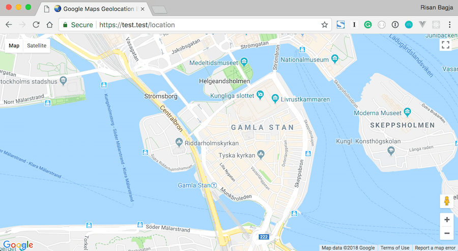
Now if we open up our page in the browser, we should see our map is successfully loaded like this:
Adding Marker to Your Map
Our next step is to learn how to add a marker to our map instance. Open the script.js file and modify it like so:
function init() {
  const initialPosition = { lat: 59.325, lng: 18.069 };

  const map = new google.maps.Map(document.getElementById('map'), {
    center: initialPosition,
    zoom: 15
  });

  const marker = new google.maps.Marker({ map, position: initialPosition });
}
Within the init function, we add a new statement that will create an instance of Marker class.
new google.maps.Marker(options);
It accepts a single argument: an object of marker’s options. The map property is where the marker will be displayed, that’s why we pass the created Map instance to this property. The position defines the marker’s position. Check out all of the available options in Marker Options Documentation.
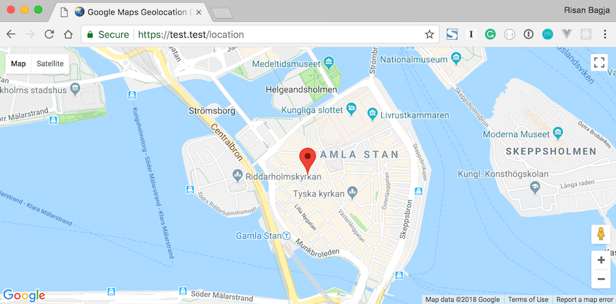
We should now see the marker placed on the map.
Get User’s Location
Our next step would be retrieving user’s location using the JavaScript Geolocation API.
Using the getCurrentPosition Method
Open up our scripts.js file again. Then add the new code section for retrieving user’s location:
function init() {
  const initialPosition = { lat: 59.325, lng: 18.069 };

  const map = new google.maps.Map(document.getElementById('map'), {
    center: initialPosition,
    zoom: 15
  });

  const marker = new google.maps.Marker({ map, position: initialPosition });

  // Get user's location
  if ('geolocation' in navigator) {
    navigator.geolocation.getCurrentPosition(
      position => console.log(`Lat: ${position.coords.latitude} Lng: ${position.coords.longitude}`),
      err => alert(`Error (${err.code}): ${err.message}`)
    );
  } else {
    alert('Geolocation is not supported by your browser.');
  }
}
The following code checks whether the GeoLocation API is supported by the browser. We simply check if the geolocation property exists within the navigator object.
if ('geolocation' in navigator) {
    // Geolocation API is supported
} else {
    // Geolocation API is not supported
    alert('Geolocation is not supported by your browser.');
}
If the GeoLocation API is supported, we can then safely use the getCurrentPosition() method to retrieve user’s location.
navigator.geolocation.getCurrentPosition(success, error, [options])
This method accepts three parameters:
success: A callback function that will be invoked once the user’s location is retrieved successfully. The callback receives aPositionobject that holds the user’s location.error: A callback function that will be invoked if user’s location is failed to retrieve. The callback accepts aPositionErrorobject.options: Is an optionalPositionOptionsobject that can be used to configure the retrieval process.
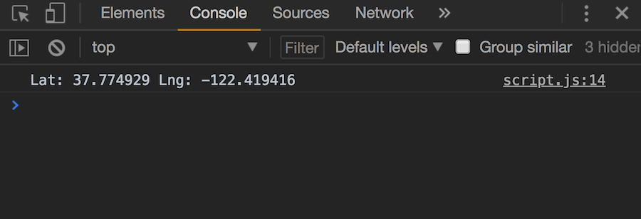
Upon successful retrieval, we simply print the user’s coordinate. And if it’s failed, we show the error message using alert.
navigator.geolocation.getCurrentPosition(
  // On success
  position => console.log(`Lat: ${position.coords.latitude} Lng: ${position.coords.longitude}`),
  // On error
  err => alert(`Error (${err.code}): ${err.message}`)
);
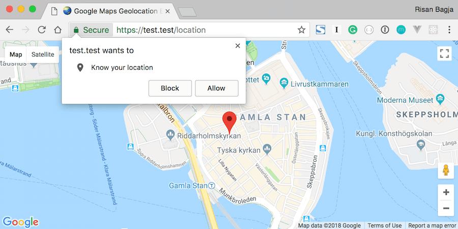
Open our page in the browser. It will ask your permission to get your current location. Click Allow to give it permission and proceed.
⚠️ Geolocation API is only available in HTTPS
Note that this Geolocation API is only available in secure contexts. So you’ll need to access your page through HTTPS protocol.
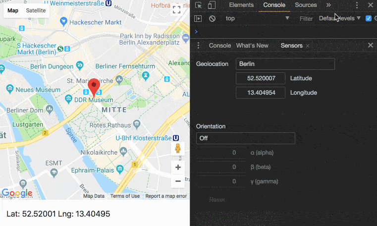
If it’s successful, you’ll get your location printed on the console similar to this:
Simulating User’s Location on Chrome
On Chrome, we can simulate the user’s location. Open up your developer tools. Click on the three-vertical-dots button on the top-right of your developer tools screen. Click on More tools » Sensors menu. It will bring a new tab named Sensors where you can easily override the position.
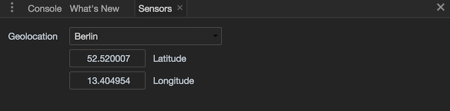
There’s also some presets for various city locations that we can choose from. Select some cities and reload the page, you should get the city’s location printed on the console.
Handling Errors
From the Sensors tab, you can also simulate the position unavailable error. From the drop-down select Location unavailable option and reload the page. You’ll get an alert like this:
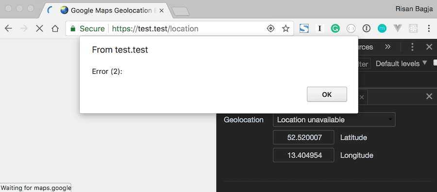
We only got the error code, but the message property is empty. Apparently, the specification already specifies that this message property is for debugging only and not to be shown directly to the user. That’s why we should rely on the code and provide our own error message instead.
The PositionError.code may have the following values:
1: The permission is denied.2: The position is unavailable, the Geolocation failed to retrieve the user’s location.3: Timeout—when the device does not return the user’s location within the giventimeoutoption.
Let’s modify our script.js to print out the appropriate error message:
// Get proper error message based on the code.
const getPositionErrorMessage = code => {
  switch (code) {
    case 1:
      return 'Permission denied.';
    case 2:
      return 'Position unavailable.';
    case 3:
      return 'Timeout reached.';
  }
}

function init() {
  // Omitted for brevity

  if ('geolocation' in navigator) {
    navigator.geolocation.getCurrentPosition(
      position => console.log(`Lat: ${position.coords.latitude} Lng: ${position.coords.longitude}`),
      err => alert(`Error (${err.code}): ${getPositionErrorMessage(err.code)}`)
    );
  } else {
    alert('Geolocation is not supported by your browser.');
  }
}
Now if we select the Location unavailable option from the Sensors tab again and reload the page. We should get an alert: Error (2): Position unavailable..
Display User’s Location on Google Maps
We successfully retrieved user’s location. But our map and marker still displaying the given initial location. Let’s modify our script.js file to properly center the map and marker to user’s location.
// Omitted for brevity

function init() {
  const initialPosition = { lat: 59.325, lng: 18.069 };

  const map = new google.maps.Map(document.getElementById('map'), {
    center: initialPosition,
    zoom: 15
  });

  const marker = new google.maps.Marker({ map, position: initialPosition });

  // Get user's location
  if ('geolocation' in navigator) {
    navigator.geolocation.getCurrentPosition(
      position => {
        console.log(`Lat: ${position.coords.latitude} Lng: ${position.coords.longitude}`);

        // Set marker's position.
        marker.setPosition({
          lat: position.coords.latitude,
          lng: position.coords.longitude
        });

        // Center map to user's position.
        map.panTo({
          lat: position.coords.latitude,
          lng: position.coords.longitude
        });
      },
      err => alert(`Error (${err.code}): ${getPositionErrorMessage(err.code)}`)
    );
  } else {
    alert('Geolocation is not supported by your browser.');
  }
}
We use the marker’s setPostion() method to change the location of the marker. We pass it an object of the retrieved user’s location.
marker.setPosition({
  lat: position.coords.latitude,
  lng: position.coords.longitude
});
And we also use the map’s panTo() method to center the map to user’s location:
map.panTo({
  lat: position.coords.latitude,
  lng: position.coords.longitude
});
Now if we load our page, both the map and marker should show the retrieved user’s location.
Let’s Refactor our Code
Our code now is getting a bit messy. Let’s refactor it by extracting each step into its own function.
const createMap = ({ lat, lng }) => {
  return new google.maps.Map(document.getElementById('map'), {
    center: { lat, lng },
    zoom: 15
  });
};

const createMarker = ({ map, position }) => {
  return new google.maps.Marker({ map, position });
};

const getCurrentPosition = ({ onSuccess, onError = () => { } }) => {
  if ('geolocation' in navigator === false) {
    return onError(new Error('Geolocation is not supported by your browser.'));
  }

  return navigator.geolocation.getCurrentPosition(onSuccess, onError);
};

const getPositionErrorMessage = code => {
  switch (code) {
    case 1:
      return 'Permission denied.';
    case 2:
      return 'Position unavailable.';
    case 3:
      return 'Timeout reached.';
    default:
      return null;
  }
}

function init() {
  const initialPosition = { lat: 59.325, lng: 18.069 };
  const map = createMap(initialPosition);
  const marker = createMarker({ map, position: initialPosition });

  getCurrentPosition({
    onSuccess: ({ coords: { latitude: lat, longitude: lng } }) => {
      marker.setPosition({ lat, lng });
      map.panTo({ lat, lng });
    },
    onError: err =>
      alert(`Error: ${getPositionErrorMessage(err.code) || err.message}`)
  });
}
We use ES2015 object destructuring to easily get access to position.coords.latitude and position.coords.longitude and rename them lat and lng accordingly:
onSuccess: ({ coords: { latitude: lat, longitude: lng } }) => {
  //
},
We also pass an Error object when the Geolocation API is not supported.
const getCurrentPosition = ({ onSuccess, onError = () => { } }) => {
  if ('geolocation' in navigator === false) {
    // Invoke onError callback and pass an error object.
    return onError(new Error('Geolocation is not supported by your browser.'));
  }

  return navigator.geolocation.getCurrentPosition(onSuccess, onError);
};
Track User’s Location with watchPosition
Up until now, we only retrieve user’s location once. How can we track user’s location continuously? By using setInterval()? Well, we can, but it’s not the best solution. To track user’s location continuously, we can use the provided watchPostion() method.
Let’s modify our script.js file to use the watchPosition instead.
// New function to track user's location.
const trackLocation = ({ onSuccess, onError = () => { } }) => {
  if ('geolocation' in navigator === false) {
    return onError(new Error('Geolocation is not supported by your browser.'));
  }

  // Use watchPosition instead.
  return navigator.geolocation.watchPosition(onSuccess, onError);
};

function init() {
  const initialPosition = { lat: 59.325, lng: 18.069 };
  const map = createMap(initialPosition);
  const marker = createMarker({ map, position: initialPosition });

  // Use the new trackLocation function.
  trackLocation({
    onSuccess: ({ coords: { latitude: lat, longitude: lng } }) => {
      marker.setPosition({ lat, lng });
      map.panTo({ lat, lng });
    },
    onError: err =>
      alert(`Error: ${getPositionErrorMessage(err.code) || err.message}`)
  });
}
The watchPosition() will be called every time the position of the device changes. This way we can easily track the user’s location.
id = navigator.geolocation.watchPosition(success[, error[, options]])
The watchPosition() accepts three parameters, it exactly the identical parameters like the one provided for getCurrentPosition(). The only difference is the error callback is optional for the watchPosition().
It also returns an id like setTimeout() or setInteval() functions. This id can be used to stop tracking user’s location with clearWatch() method.
If we reload our page, both the marker and the map position should now be updated every time the location is changed.
The PositionOptions
Both getCurrentPosition() and watchPosition() accept the optional third parameter. It’s an object of PositionOptions. There are three properties that we can configure:
enableHighAccuracy: It’s abooleanto indicate whether we’d like to get the best possible accuracy or not. Enabling this option may result in slower response time and increase power consumption.timeout: It’s alongvalue in milliseconds that will limit the time for a device to return user’s location. If the device hasn’t returned the location within the specified time, it will throw a timeout error. By default, the value isInfinitywhich means it will never timeout.maximumAge: It’s alongvalue in milliseconds representing the maximum age of a cached position. By default, it set to0and it means that we don’t want the device to use a cached position.
Let’s configure our trackLocation() function to enable the high accuracy and set a maximum timeout to 5 seconds.
const trackLocation = ({ onSuccess, onError = () => { } }) => {
  // Omitted for brevity

  return navigator.geolocation.watchPosition(onSuccess, onError, {
    enableHighAccuracy: true,
    timeout: 5000,
    maximumAge: 0
  });
};
The Final Touch
For the final touch, let’s integrate both the retrieved user’s coordinate and any error message into the UI. Open the index.html file and add a new div for displaying this information:
<main class="container">
    <div id="map" class="map"></div>
    <!-- For displaying user's coordinate or error message. -->
    <div id="info" class="info"></div>
</main>
Now open the styles.css file and add the following rules:
.info {
    padding: 1rem;
    margin: 0;
}

.info.error {
    color: #fff;
    background: #dc3545;
}
Finally, let’s update our script.js to print out the coordinate and the error into the #info div.
function init() {
  const initialPosition = { lat: 59.325, lng: 18.069 };
  const map = createMap(initialPosition);
  const marker = createMarker({ map, position: initialPosition });
  const $info = document.getElementById('info');

  trackLocation({
    onSuccess: ({ coords: { latitude: lat, longitude: lng } }) => {
      marker.setPosition({ lat, lng });
      map.panTo({ lat, lng });
      // Print out the user's location.
      $info.textContent = `Lat: ${lat} Lng: ${lng}`;
      // Don't forget to remove any error class name.
      $info.classList.remove('error');
    },
    onError: err => {
      // Print out the error message.
      $info.textContent = `Error: ${getPositionErrorMessage(err.code) || err.message}`;
      // Add error class name.
      $info.classList.add('error');
    }
  });
}
Now we should get a nice user’s coordinate and error at the bottom of the map.
You can check out the live demo and play around with it. You can also get the source for this tutorial on Github: google-maps-geolocation-example.
Credits:
- Globe by Nicole Harrington on Unsplash.